
Search and Load CMIP6 Data via ESGF / OPeNDAP
This notebooks shows how to search and load data via Earth System Grid Federation infrastructure. This infrastructure works great and is the foundation of the CMIP6 distribution system.
The main technologies used here are the ESGF search API, used to figure out what data we want, and OPeNDAP, a remote data access protocol over HTTP.
[1]:
from matplotlib import pyplot as plt
import numpy as np
import pandas as pd
import xarray as xr

xr.set_options(display_style='html')
%matplotlib inline
%config InlineBackend.figure_format = 'retina'
Search using ESGF API
[2]:
#!/usr/bin/env python
from __future__ import print_function
import requests
import xml.etree.ElementTree as ET
import numpy

# Author: Unknown
# I got the original version from a word document published by ESGF
# https://docs.google.com/document/d/1pxz1Kd3JHfFp8vR2JCVBfApbsHmbUQQstifhGNdc6U0/edit?usp=sharing

# API AT: https://github.com/ESGF/esgf.github.io/wiki/ESGF_Search_REST_API#results-pagination

def esgf_search(server="https://esgf-node.llnl.gov/esg-search/search",
                files_type="OPENDAP", local_node=True, project="CMIP6",
                verbose=False, format="application%2Fsolr%2Bjson",
                use_csrf=False, **search):
    client = requests.session()
    payload = search
    payload["project"] = project
    payload["type"]= "File"
    if local_node:
        payload["distrib"] = "false"
    if use_csrf:
        client.get(server)
        if 'csrftoken' in client.cookies:
            # Django 1.6 and up
            csrftoken = client.cookies['csrftoken']
        else:
            # older versions
            csrftoken = client.cookies['csrf']
        payload["csrfmiddlewaretoken"] = csrftoken

    payload["format"] = format

    offset = 0
    numFound = 10000
    all_files = []
    files_type = files_type.upper()
    while offset < numFound:
        payload["offset"] = offset
        url_keys = []
        for k in payload:
            url_keys += ["{}={}".format(k, payload[k])]

        url = "{}/?{}".format(server, "&".join(url_keys))
        print(url)
        r = client.get(url)
        r.raise_for_status()
        resp = r.json()["response"]
        numFound = int(resp["numFound"])
        resp = resp["docs"]
        offset += len(resp)
        for d in resp:
            if verbose:
                for k in d:
                    print("{}: {}".format(k,d[k]))
            url = d["url"]
            for f in d["url"]:
                sp = f.split("|")
                if sp[-1] == files_type:
                    all_files.append(sp[0].split(".html")[0])
    return sorted(all_files)
[3]:
result = esgf_search(activity_id='CMIP', table_id='Amon', variable_id='tas', experiment_id='historical',
                  institution_id="NCAR", source_id="CESM2", member_id="r10i1p1f1")
result
https://esgf-node.llnl.gov/esg-search/search/?activity_id=CMIP&table_id=Amon&variable_id=tas&experiment_id=historical&institution_id=NCAR&source_id=CESM2&member_id=r10i1p1f1&project=CMIP6&type=File&distrib=false&format=application%2Fsolr%2Bjson&offset=0
https://esgf-node.llnl.gov/esg-search/search/?activity_id=CMIP&table_id=Amon&variable_id=tas&experiment_id=historical&institution_id=NCAR&source_id=CESM2&member_id=r10i1p1f1&project=CMIP6&type=File&distrib=false&format=application%2Fsolr%2Bjson&offset=10
[3]:
['http://aims3.llnl.gov/thredds/dodsC/css03_data/CMIP6/CMIP/NCAR/CESM2/historical/r10i1p1f1/Amon/tas/gn/v20190313/tas_Amon_CESM2_historical_r10i1p1f1_gn_185001-189912.nc',
 'http://aims3.llnl.gov/thredds/dodsC/css03_data/CMIP6/CMIP/NCAR/CESM2/historical/r10i1p1f1/Amon/tas/gn/v20190313/tas_Amon_CESM2_historical_r10i1p1f1_gn_190001-194912.nc',
 'http://aims3.llnl.gov/thredds/dodsC/css03_data/CMIP6/CMIP/NCAR/CESM2/historical/r10i1p1f1/Amon/tas/gn/v20190313/tas_Amon_CESM2_historical_r10i1p1f1_gn_195001-199912.nc',
 'http://aims3.llnl.gov/thredds/dodsC/css03_data/CMIP6/CMIP/NCAR/CESM2/historical/r10i1p1f1/Amon/tas/gn/v20190313/tas_Amon_CESM2_historical_r10i1p1f1_gn_200001-201412.nc',
 'http://esgf-data.ucar.edu/thredds/dodsC/esg_dataroot/CMIP6/CMIP/NCAR/CESM2/historical/r10i1p1f1/Amon/tas/gn/v20190313/tas_Amon_CESM2_historical_r10i1p1f1_gn_185001-189912.nc',
 'http://esgf-data.ucar.edu/thredds/dodsC/esg_dataroot/CMIP6/CMIP/NCAR/CESM2/historical/r10i1p1f1/Amon/tas/gn/v20190313/tas_Amon_CESM2_historical_r10i1p1f1_gn_190001-194912.nc',
 'http://esgf-data.ucar.edu/thredds/dodsC/esg_dataroot/CMIP6/CMIP/NCAR/CESM2/historical/r10i1p1f1/Amon/tas/gn/v20190313/tas_Amon_CESM2_historical_r10i1p1f1_gn_195001-199912.nc',
 'http://esgf-data.ucar.edu/thredds/dodsC/esg_dataroot/CMIP6/CMIP/NCAR/CESM2/historical/r10i1p1f1/Amon/tas/gn/v20190313/tas_Amon_CESM2_historical_r10i1p1f1_gn_200001-201412.nc',
 'http://esgf-data3.diasjp.net/thredds/dodsC/esg_dataroot/CMIP6/CMIP/NCAR/CESM2/historical/r10i1p1f1/Amon/tas/gn/v20190313/tas_Amon_CESM2_historical_r10i1p1f1_gn_185001-189912.nc',
 'http://esgf-data3.diasjp.net/thredds/dodsC/esg_dataroot/CMIP6/CMIP/NCAR/CESM2/historical/r10i1p1f1/Amon/tas/gn/v20190313/tas_Amon_CESM2_historical_r10i1p1f1_gn_190001-194912.nc',
 'http://esgf-data3.diasjp.net/thredds/dodsC/esg_dataroot/CMIP6/CMIP/NCAR/CESM2/historical/r10i1p1f1/Amon/tas/gn/v20190313/tas_Amon_CESM2_historical_r10i1p1f1_gn_195001-199912.nc',
 'http://esgf-data3.diasjp.net/thredds/dodsC/esg_dataroot/CMIP6/CMIP/NCAR/CESM2/historical/r10i1p1f1/Amon/tas/gn/v20190313/tas_Amon_CESM2_historical_r10i1p1f1_gn_200001-201412.nc']
Load Data with Xarray
These are OPeNDAP endpoints. Xarray, together with the netCDF4 python library, allow lazy loading.
[4]:
# there are mulitple sources of the same data--need to pick one
files_to_open = result[-4:]

ds = xr.open_mfdataset(files_to_open, combine='by_coords')
ds
/srv/conda/envs/notebook/lib/python3.7/site-packages/xarray/conventions.py:500: SerializationWarning: variable 'tas' has multiple fill values {1e+20, 1e+20}, decoding all values to NaN.
  decode_timedelta=decode_timedelta,
[4]:
<xarray.Dataset>
Dimensions:    (lat: 192, lon: 288, nbnd: 2, time: 1980)
Coordinates:
  * lat        (lat) float64 -90.0 -89.06 -88.12 -87.17 ... 88.12 89.06 90.0
  * lon        (lon) float64 0.0 1.25 2.5 3.75 5.0 ... 355.0 356.2 357.5 358.8
  * time       (time) object 1850-01-15 12:00:00 ... 2014-12-15 12:00:00
Dimensions without coordinates: nbnd
Data variables:
    time_bnds  (time, nbnd) object dask.array<chunksize=(600, 2), meta=np.ndarray>
    lat_bnds   (time, lat, nbnd) float64 dask.array<chunksize=(600, 192, 2), meta=np.ndarray>
    lon_bnds   (time, lon, nbnd) float64 dask.array<chunksize=(600, 288, 2), meta=np.ndarray>
    tas        (time, lat, lon) float32 dask.array<chunksize=(600, 192, 288), meta=np.ndarray>
Attributes:
    Conventions:                     CF-1.7 CMIP-6.2
    activity_id:                     CMIP
    branch_method:                   standard
    branch_time_in_child:            674885.0
    branch_time_in_parent:           306600.0
    case_id:                         24
    cesm_casename:                   b.e21.BHIST.f09_g17.CMIP6-historical.010
    contact:                         cesm_cmip6@ucar.edu
    creation_date:                   2019-03-12T06:39:18Z
    data_specs_version:              01.00.29
    experiment:                      Simulation of recent past (1850 to 2014)...
    experiment_id:                   historical
    external_variables:              areacella
    forcing_index:                   1
    frequency:                       mon
    further_info_url:                https://furtherinfo.es-doc.org/CMIP6.NCA...
    grid:                            native 0.9x1.25 finite volume grid (192x...
    grid_label:                      gn
    initialization_index:            1
    institution:                     National Center for Atmospheric Research...
    institution_id:                  NCAR
    license:                         CMIP6 model data produced by <The Nation...
    mip_era:                         CMIP6
    model_doi_url:                   https://doi.org/10.5065/D67H1H0V
    nominal_resolution:              100 km
    parent_activity_id:              CMIP
    parent_experiment_id:            piControl
    parent_mip_era:                  CMIP6
    parent_source_id:                CESM2
    parent_time_units:               days since 0001-01-01 00:00:00
    parent_variant_label:            r1i1p1f1
    physics_index:                   1
    product:                         model-output
    realization_index:               10
    realm:                           atmos
    source:                          CESM2 (2017): atmosphere: CAM6 (0.9x1.25...
    source_id:                       CESM2
    source_type:                     AOGCM BGC
    sub_experiment:                  none
    sub_experiment_id:               none
    table_id:                        Amon
    tracking_id:                     hdl:21.14100/e47b79db-3925-45a7-9c0a-679...
    variable_id:                     tas
    variant_info:                    CMIP6 20th century experiments (1850-201...
    variant_label:                   r10i1p1f1
    DODS_EXTRA.Unlimited_Dimension:  time
xarray.Dataset
- lat: 192
- lon: 288
- nbnd: 2
- time: 1980
- lat(lat)float64-90.0 -89.06 -88.12 ... 89.06 90.0
- axis :
- Y
- bounds :
- lat_bnds
- standard_name :
- latitude
- title :
- Latitude
- type :
- double
- units :
- degrees_north
- valid_max :
- 90.0
- valid_min :
- -90.0
- _ChunkSizes :
- 192
array([-90. , -89.057592, -88.115183, -87.172775, -86.230366, -85.287958, -84.34555 , -83.403141, -82.460733, -81.518325, -80.575916, -79.633508, -78.691099, -77.748691, -76.806283, -75.863874, -74.921466, -73.979058, -73.036649, -72.094241, -71.151832, -70.209424, -69.267016, -68.324607, -67.382199, -66.439791, -65.497382, -64.554974, -63.612565, -62.670157, -61.727749, -60.78534 , -59.842932, -58.900524, -57.958115, -57.015707, -56.073298, -55.13089 , -54.188482, -53.246073, -52.303665, -51.361257, -50.418848, -49.47644 , -48.534031, -47.591623, -46.649215, -45.706806, -44.764398, -43.82199 , -42.879581, -41.937173, -40.994764, -40.052356, -39.109948, -38.167539, -37.225131, -36.282723, -35.340314, -34.397906, -33.455497, -32.513089, -31.570681, -30.628272, -29.685864, -28.743455, -27.801047, -26.858639, -25.91623 , -24.973822, -24.031414, -23.089005, -22.146597, -21.204188, -20.26178 , -19.319372, -18.376963, -17.434555, -16.492147, -15.549738, -14.60733 , -13.664921, -12.722513, -11.780105, -10.837696, -9.895288, -8.95288 , -8.010471, -7.068063, -6.125654, -5.183246, -4.240838, -3.298429, -2.356021, -1.413613, -0.471204, 0.471204, 1.413613, 2.356021, 3.298429, 4.240838, 5.183246, 6.125654, 7.068063, 8.010471, 8.95288 , 9.895288, 10.837696, 11.780105, 12.722513, 13.664921, 14.60733 , 15.549738, 16.492147, 17.434555, 18.376963, 19.319372, 20.26178 , 21.204188, 22.146597, 23.089005, 24.031414, 24.973822, 25.91623 , 26.858639, 27.801047, 28.743455, 29.685864, 30.628272, 31.570681, 32.513089, 33.455497, 34.397906, 35.340314, 36.282723, 37.225131, 38.167539, 39.109948, 40.052356, 40.994764, 41.937173, 42.879581, 43.82199 , 44.764398, 45.706806, 46.649215, 47.591623, 48.534031, 49.47644 , 50.418848, 51.361257, 52.303665, 53.246073, 54.188482, 55.13089 , 56.073298, 57.015707, 57.958115, 58.900524, 59.842932, 60.78534 , 61.727749, 62.670157, 63.612565, 64.554974, 65.497382, 66.439791, 67.382199, 68.324607, 69.267016, 70.209424, 71.151832, 72.094241, 73.036649, 73.979058, 74.921466, 75.863874, 76.806283, 77.748691, 78.691099, 79.633508, 80.575916, 81.518325, 82.460733, 83.403141, 84.34555 , 85.287958, 86.230366, 87.172775, 88.115183, 89.057592, 90. ]) - lon(lon)float640.0 1.25 2.5 ... 356.2 357.5 358.8
- axis :
- X
- bounds :
- lon_bnds
- standard_name :
- longitude
- title :
- Longitude
- type :
- double
- units :
- degrees_east
- valid_max :
- 360.0
- valid_min :
- 0.0
- _ChunkSizes :
- 288
array([ 0. , 1.25, 2.5 , ..., 356.25, 357.5 , 358.75])
- time(time)object1850-01-15 12:00:00 ... 2014-12-...
- axis :
- T
- bounds :
- time_bnds
- standard_name :
- time
- title :
- time
- type :
- double
- _ChunkSizes :
- 512
array([cftime.DatetimeNoLeap(1850, 1, 15, 12, 0, 0, 0),
       cftime.DatetimeNoLeap(1850, 2, 14, 0, 0, 0, 0),
       cftime.DatetimeNoLeap(1850, 3, 15, 12, 0, 0, 0), ...,
       cftime.DatetimeNoLeap(2014, 10, 15, 12, 0, 0, 0),
       cftime.DatetimeNoLeap(2014, 11, 15, 0, 0, 0, 0),
       cftime.DatetimeNoLeap(2014, 12, 15, 12, 0, 0, 0)], dtype=object)
- time_bnds(time, nbnd)objectdask.array<chunksize=(600, 2), meta=np.ndarray>
- _ChunkSizes :
- [1 2]
Array Chunk Bytes 31.68 kB 9.60 kB Shape (1980, 2) (600, 2) Count 12 Tasks 4 Chunks Type object numpy.ndarray - lat_bnds(time, lat, nbnd)float64dask.array<chunksize=(600, 192, 2), meta=np.ndarray>
- units :
- degrees_north
- _ChunkSizes :
- [192 2]
Array Chunk Bytes 6.08 MB 1.84 MB Shape (1980, 192, 2) (600, 192, 2) Count 16 Tasks 4 Chunks Type float64 numpy.ndarray - lon_bnds(time, lon, nbnd)float64dask.array<chunksize=(600, 288, 2), meta=np.ndarray>
- units :
- degrees_east
- _ChunkSizes :
- [288 2]
Array Chunk Bytes 9.12 MB 2.76 MB Shape (1980, 288, 2) (600, 288, 2) Count 16 Tasks 4 Chunks Type float64 numpy.ndarray - tas(time, lat, lon)float32dask.array<chunksize=(600, 192, 288), meta=np.ndarray>
- cell_measures :
- area: areacella
- cell_methods :
- area: time: mean
- comment :
- near-surface (usually, 2 meter) air temperature
- description :
- near-surface (usually, 2 meter) air temperature
- frequency :
- mon
- id :
- tas
- long_name :
- Near-Surface Air Temperature
- mipTable :
- Amon
- out_name :
- tas
- prov :
- Amon ((isd.003))
- realm :
- atmos
- standard_name :
- air_temperature
- time :
- time
- time_label :
- time-mean
- time_title :
- Temporal mean
- title :
- Near-Surface Air Temperature
- type :
- real
- units :
- K
- variable_id :
- tas
- _ChunkSizes :
- [ 1 192 288]
Array Chunk Bytes 437.94 MB 132.71 MB Shape (1980, 192, 288) (600, 192, 288) Count 12 Tasks 4 Chunks Type float32 numpy.ndarray
- Conventions :
- CF-1.7 CMIP-6.2
- activity_id :
- CMIP
- branch_method :
- standard
- branch_time_in_child :
- 674885.0
- branch_time_in_parent :
- 306600.0
- case_id :
- 24
- cesm_casename :
- b.e21.BHIST.f09_g17.CMIP6-historical.010
- contact :
- cesm_cmip6@ucar.edu
- creation_date :
- 2019-03-12T06:39:18Z
- data_specs_version :
- 01.00.29
- experiment :
- Simulation of recent past (1850 to 2014). Impose changing conditions (consistent with observations). Should be initialised from a point early enough in the pre-industrial control run to ensure that the end of all the perturbed runs branching from the end of this historical run end before the end of the control. Only one ensemble member is requested but modelling groups are strongly encouraged to submit at least three ensemble members of their CMIP historical simulation.
- experiment_id :
- historical
- external_variables :
- areacella
- forcing_index :
- 1
- frequency :
- mon
- further_info_url :
- https://furtherinfo.es-doc.org/CMIP6.NCAR.CESM2.historical.none.r10i1p1f1
- grid :
- native 0.9x1.25 finite volume grid (192x288 latxlon)
- grid_label :
- gn
- initialization_index :
- 1
- institution :
- National Center for Atmospheric Research, Climate and Global Dynamics Laboratory, 1850 Table Mesa Drive, Boulder, CO 80305, USA
- institution_id :
- NCAR
- license :
- CMIP6 model data produced by <The National Center for Atmospheric Research> is licensed under a Creative Commons Attribution-[]ShareAlike 4.0 International License (https://creativecommons.org/licenses/). Consult https://pcmdi.llnl.gov/CMIP6/TermsOfUse for terms of use governing CMIP6 output, including citation requirements and proper acknowledgment. Further information about this data, including some limitations, can be found via the further_info_url (recorded as a global attribute in this file)[]. The data producers and data providers make no warranty, either express or implied, including, but not limited to, warranties of merchantability and fitness for a particular purpose. All liabilities arising from the supply of the information (including any liability arising in negligence) are excluded to the fullest extent permitted by law.
- mip_era :
- CMIP6
- model_doi_url :
- https://doi.org/10.5065/D67H1H0V
- nominal_resolution :
- 100 km
- parent_activity_id :
- CMIP
- parent_experiment_id :
- piControl
- parent_mip_era :
- CMIP6
- parent_source_id :
- CESM2
- parent_time_units :
- days since 0001-01-01 00:00:00
- parent_variant_label :
- r1i1p1f1
- physics_index :
- 1
- product :
- model-output
- realization_index :
- 10
- realm :
- atmos
- source :
- CESM2 (2017): atmosphere: CAM6 (0.9x1.25 finite volume grid; 288 x 192 longitude/latitude; 32 levels; top level 2.25 mb); ocean: POP2 (320x384 longitude/latitude; 60 levels; top grid cell 0-10 m); sea_ice: CICE5.1 (same grid as ocean); land: CLM5 0.9x1.25 finite volume grid; 288 x 192 longitude/latitude; 32 levels; top level 2.25 mb); aerosol: MAM4 (0.9x1.25 finite volume grid; 288 x 192 longitude/latitude; 32 levels; top level 2.25 mb); atmoschem: MAM4 (0.9x1.25 finite volume grid; 288 x 192 longitude/latitude; 32 levels; top level 2.25 mb); landIce: CISM2.1; ocnBgchem: MARBL (320x384 longitude/latitude; 60 levels; top grid cell 0-10 m)
- source_id :
- CESM2
- source_type :
- AOGCM BGC
- sub_experiment :
- none
- sub_experiment_id :
- none
- table_id :
- Amon
- tracking_id :
- hdl:21.14100/e47b79db-3925-45a7-9c0a-6799c2f1e8ae
- variable_id :
- tas
- variant_info :
- CMIP6 20th century experiments (1850-2014) with CAM6, interactive land (CLM5), coupled ocean (POP2) with biogeochemistry (MARBL), interactive sea ice (CICE5.1), and non-evolving land ice (CISM2.1)
- variant_label :
- r10i1p1f1
- DODS_EXTRA.Unlimited_Dimension :
- time
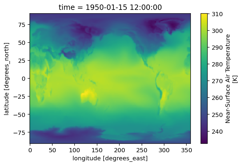
Plot a map from a specific date.
[5]:
ds.tas.sel(time='1950-01').squeeze().plot()
[5]:
<matplotlib.collections.QuadMesh at 0x7f511a086f10>
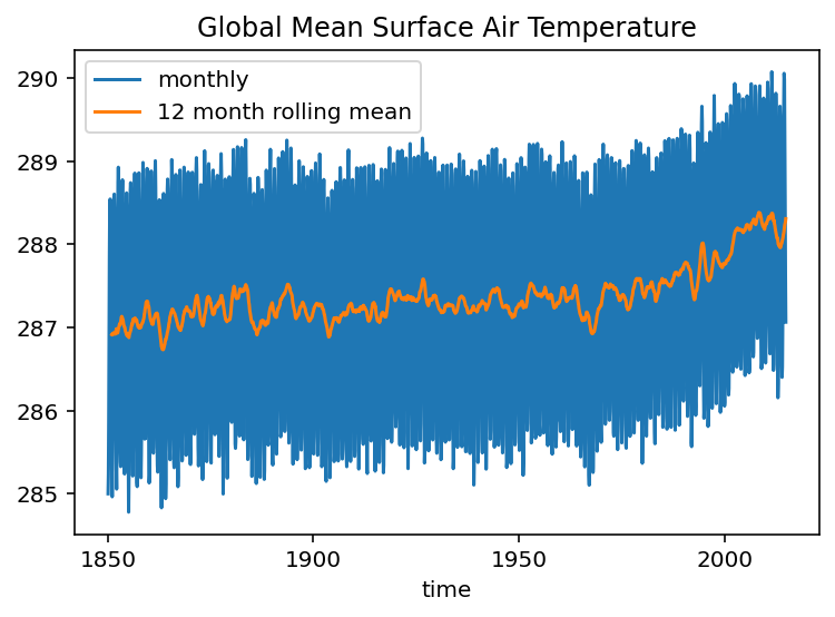
Create a timeseries of global-average surface air temperature. For this we need the area weighting factor for each gridpoint.
[6]:
files_area = esgf_search(variable_id='areacella', activity_id='CMIP',
                         experiment_id='historical', institution_id="NCAR", source_id="CESM2")
ds_area = xr.open_dataset(files_area[0])
ds_area
https://esgf-node.llnl.gov/esg-search/search/?variable_id=areacella&activity_id=CMIP&experiment_id=historical&institution_id=NCAR&source_id=CESM2&project=CMIP6&type=File&distrib=false&format=application%2Fsolr%2Bjson&offset=0
https://esgf-node.llnl.gov/esg-search/search/?variable_id=areacella&activity_id=CMIP&experiment_id=historical&institution_id=NCAR&source_id=CESM2&project=CMIP6&type=File&distrib=false&format=application%2Fsolr%2Bjson&offset=10
https://esgf-node.llnl.gov/esg-search/search/?variable_id=areacella&activity_id=CMIP&experiment_id=historical&institution_id=NCAR&source_id=CESM2&project=CMIP6&type=File&distrib=false&format=application%2Fsolr%2Bjson&offset=20
https://esgf-node.llnl.gov/esg-search/search/?variable_id=areacella&activity_id=CMIP&experiment_id=historical&institution_id=NCAR&source_id=CESM2&project=CMIP6&type=File&distrib=false&format=application%2Fsolr%2Bjson&offset=30
/srv/conda/envs/notebook/lib/python3.7/site-packages/xarray/conventions.py:500: SerializationWarning: variable 'areacella' has multiple fill values {1e+20, 1e+20}, decoding all values to NaN.
  decode_timedelta=decode_timedelta,
[6]:
<xarray.Dataset>
Dimensions:    (lat: 192, lon: 288, nbnd: 2)
Coordinates:
  * lat        (lat) float64 -90.0 -89.06 -88.12 -87.17 ... 88.12 89.06 90.0
  * lon        (lon) float64 0.0 1.25 2.5 3.75 5.0 ... 355.0 356.2 357.5 358.8
Dimensions without coordinates: nbnd
Data variables:
    lat_bnds   (lat, nbnd) float64 -90.0 -89.53 -89.53 ... 89.53 89.53 90.0
    lon_bnds   (lon, nbnd) float64 -0.625 0.625 0.625 ... 358.1 358.1 359.4
    areacella  (lat, lon) float32 29948368.0 29948368.0 ... 29948368.0
Attributes:
    _NCProperties:          version=1|netcdflibversion=4.4.1.1|hdf5libversion...
    Conventions:            CF-1.7 CMIP-6.2
    activity_id:            CMIP
    branch_method:          standard
    branch_time_in_child:   674885.0
    branch_time_in_parent:  306600.0
    case_id:                24
    cesm_casename:          b.e21.BHIST.f09_g17.CMIP6-historical.010
    contact:                cesm_cmip6@ucar.edu
    creation_date:          2019-03-12T06:40:59Z
    data_specs_version:     01.00.29
    experiment:             Simulation of recent past (1850 to 2014). Impose ...
    experiment_id:          historical
    forcing_index:          1
    frequency:              fx
    further_info_url:       https://furtherinfo.es-doc.org/CMIP6.NCAR.CESM2.h...
    grid:                   native 0.9x1.25 finite volume grid (192x288 latxlon)
    grid_label:             gn
    initialization_index:   1
    institution:            National Center for Atmospheric Research, Climate...
    institution_id:         NCAR
    license:                CMIP6 model data produced by <The National Center...
    mip_era:                CMIP6
    model_doi_url:          https://doi.org/10.5065/D67H1H0V
    nominal_resolution:     100 km
    parent_activity_id:     CMIP
    parent_experiment_id:   piControl
    parent_mip_era:         CMIP6
    parent_source_id:       CESM2
    parent_time_units:      days since 0001-01-01 00:00:00
    parent_variant_label:   r1i1p1f1
    physics_index:          1
    product:                model-output
    realization_index:      10
    realm:                  atmos land
    source:                 CESM2 (2017): atmosphere: CAM6 (0.9x1.25 finite v...
    source_id:              CESM2
    source_type:            AOGCM BGC
    sub_experiment:         none
    sub_experiment_id:      none
    table_id:               fx
    tracking_id:            hdl:21.14100/54fe4682-51a1-43ca-a7d5-66b7bca3f8c8
    variable_id:            areacella
    variant_info:           CMIP6 20th century experiments (1850-2014) with C...
    variant_label:          r10i1p1f1
xarray.Dataset
- lat: 192
- lon: 288
- nbnd: 2
- lat(lat)float64-90.0 -89.06 -88.12 ... 89.06 90.0
- axis :
- Y
- bounds :
- lat_bnds
- standard_name :
- latitude
- title :
- Latitude
- type :
- double
- units :
- degrees_north
- valid_max :
- 90.0
- valid_min :
- -90.0
- _ChunkSizes :
- 192
array([-90. , -89.057592, -88.115183, -87.172775, -86.230366, -85.287958, -84.34555 , -83.403141, -82.460733, -81.518325, -80.575916, -79.633508, -78.691099, -77.748691, -76.806283, -75.863874, -74.921466, -73.979058, -73.036649, -72.094241, -71.151832, -70.209424, -69.267016, -68.324607, -67.382199, -66.439791, -65.497382, -64.554974, -63.612565, -62.670157, -61.727749, -60.78534 , -59.842932, -58.900524, -57.958115, -57.015707, -56.073298, -55.13089 , -54.188482, -53.246073, -52.303665, -51.361257, -50.418848, -49.47644 , -48.534031, -47.591623, -46.649215, -45.706806, -44.764398, -43.82199 , -42.879581, -41.937173, -40.994764, -40.052356, -39.109948, -38.167539, -37.225131, -36.282723, -35.340314, -34.397906, -33.455497, -32.513089, -31.570681, -30.628272, -29.685864, -28.743455, -27.801047, -26.858639, -25.91623 , -24.973822, -24.031414, -23.089005, -22.146597, -21.204188, -20.26178 , -19.319372, -18.376963, -17.434555, -16.492147, -15.549738, -14.60733 , -13.664921, -12.722513, -11.780105, -10.837696, -9.895288, -8.95288 , -8.010471, -7.068063, -6.125654, -5.183246, -4.240838, -3.298429, -2.356021, -1.413613, -0.471204, 0.471204, 1.413613, 2.356021, 3.298429, 4.240838, 5.183246, 6.125654, 7.068063, 8.010471, 8.95288 , 9.895288, 10.837696, 11.780105, 12.722513, 13.664921, 14.60733 , 15.549738, 16.492147, 17.434555, 18.376963, 19.319372, 20.26178 , 21.204188, 22.146597, 23.089005, 24.031414, 24.973822, 25.91623 , 26.858639, 27.801047, 28.743455, 29.685864, 30.628272, 31.570681, 32.513089, 33.455497, 34.397906, 35.340314, 36.282723, 37.225131, 38.167539, 39.109948, 40.052356, 40.994764, 41.937173, 42.879581, 43.82199 , 44.764398, 45.706806, 46.649215, 47.591623, 48.534031, 49.47644 , 50.418848, 51.361257, 52.303665, 53.246073, 54.188482, 55.13089 , 56.073298, 57.015707, 57.958115, 58.900524, 59.842932, 60.78534 , 61.727749, 62.670157, 63.612565, 64.554974, 65.497382, 66.439791, 67.382199, 68.324607, 69.267016, 70.209424, 71.151832, 72.094241, 73.036649, 73.979058, 74.921466, 75.863874, 76.806283, 77.748691, 78.691099, 79.633508, 80.575916, 81.518325, 82.460733, 83.403141, 84.34555 , 85.287958, 86.230366, 87.172775, 88.115183, 89.057592, 90. ]) - lon(lon)float640.0 1.25 2.5 ... 356.2 357.5 358.8
- axis :
- X
- bounds :
- lon_bnds
- standard_name :
- longitude
- title :
- Longitude
- type :
- double
- units :
- degrees_east
- valid_max :
- 360.0
- valid_min :
- 0.0
- _ChunkSizes :
- 288
array([ 0. , 1.25, 2.5 , ..., 356.25, 357.5 , 358.75])
- lat_bnds(lat, nbnd)float64...
- units :
- degrees_north
- _ChunkSizes :
- [192 2]
array([[-90. , -89.528796], [-89.528796, -88.586387], [-88.586387, -87.643979], ..., [ 87.643979, 88.586387], [ 88.586387, 89.528796], [ 89.528796, 90. ]]) - lon_bnds(lon, nbnd)float64...
- units :
- degrees_east
- _ChunkSizes :
- [288 2]
array([[ -0.625, 0.625], [ 0.625, 1.875], [ 1.875, 3.125], ..., [355.625, 356.875], [356.875, 358.125], [358.125, 359.375]]) - areacella(lat, lon)float32...
- cell_methods :
- area: sum
- comment :
- Cell areas for any grid used to report atmospheric variables and any other variable using that grid (e.g., soil moisture content). These cell areas should be defined to enable exact calculation of global integrals (e.g., of vertical fluxes of energy at the surface and top of the atmosphere).
- description :
- Cell areas for any grid used to report atmospheric variables and any other variable using that grid (e.g., soil moisture content). These cell areas should be defined to enable exact calculation of global integrals (e.g., of vertical fluxes of energy at the surface and top of the atmosphere).
- frequency :
- fx
- id :
- areacella
- long_name :
- Grid-Cell Area for Atmospheric Grid Variables
- mipTable :
- fx
- out_name :
- areacella
- prov :
- fx ((isd.003))
- realm :
- atmos land
- standard_name :
- cell_area
- time_label :
- None
- time_title :
- No temporal dimensions ... fixed field
- title :
- Grid-Cell Area for Atmospheric Grid Variables
- type :
- real
- units :
- m2
- variable_id :
- areacella
- _ChunkSizes :
- [192 288]
array([[2.994837e+07, 2.994837e+07, 2.994837e+07, ..., 2.994837e+07,
        2.994837e+07, 2.994837e+07],
       [2.395748e+08, 2.395748e+08, 2.395748e+08, ..., 2.395748e+08,
        2.395748e+08, 2.395748e+08],
       [4.790848e+08, 4.790848e+08, 4.790848e+08, ..., 4.790848e+08,
        4.790848e+08, 4.790848e+08],
       ...,
       [4.790848e+08, 4.790848e+08, 4.790848e+08, ..., 4.790848e+08,
        4.790848e+08, 4.790848e+08],
       [2.395748e+08, 2.395748e+08, 2.395748e+08, ..., 2.395748e+08,
        2.395748e+08, 2.395748e+08],
       [2.994837e+07, 2.994837e+07, 2.994837e+07, ..., 2.994837e+07,
        2.994837e+07, 2.994837e+07]], dtype=float32)
- _NCProperties :
- version=1|netcdflibversion=4.4.1.1|hdf5libversion=1.8.18
- Conventions :
- CF-1.7 CMIP-6.2
- activity_id :
- CMIP
- branch_method :
- standard
- branch_time_in_child :
- 674885.0
- branch_time_in_parent :
- 306600.0
- case_id :
- 24
- cesm_casename :
- b.e21.BHIST.f09_g17.CMIP6-historical.010
- contact :
- cesm_cmip6@ucar.edu
- creation_date :
- 2019-03-12T06:40:59Z
- data_specs_version :
- 01.00.29
- experiment :
- Simulation of recent past (1850 to 2014). Impose changing conditions (consistent with observations). Should be initialised from a point early enough in the pre-industrial control run to ensure that the end of all the perturbed runs branching from the end of this historical run end before the end of the control. Only one ensemble member is requested but modelling groups are strongly encouraged to submit at least three ensemble members of their CMIP historical simulation.
- experiment_id :
- historical
- forcing_index :
- 1
- frequency :
- fx
- further_info_url :
- https://furtherinfo.es-doc.org/CMIP6.NCAR.CESM2.historical.none.r10i1p1f1
- grid :
- native 0.9x1.25 finite volume grid (192x288 latxlon)
- grid_label :
- gn
- initialization_index :
- 1
- institution :
- National Center for Atmospheric Research, Climate and Global Dynamics Laboratory, 1850 Table Mesa Drive, Boulder, CO 80305, USA
- institution_id :
- NCAR
- license :
- CMIP6 model data produced by <The National Center for Atmospheric Research> is licensed under a Creative Commons Attribution-[]ShareAlike 4.0 International License (https://creativecommons.org/licenses/). Consult https://pcmdi.llnl.gov/CMIP6/TermsOfUse for terms of use governing CMIP6 output, including citation requirements and proper acknowledgment. Further information about this data, including some limitations, can be found via the further_info_url (recorded as a global attribute in this file)[]. The data producers and data providers make no warranty, either express or implied, including, but not limited to, warranties of merchantability and fitness for a particular purpose. All liabilities arising from the supply of the information (including any liability arising in negligence) are excluded to the fullest extent permitted by law.
- mip_era :
- CMIP6
- model_doi_url :
- https://doi.org/10.5065/D67H1H0V
- nominal_resolution :
- 100 km
- parent_activity_id :
- CMIP
- parent_experiment_id :
- piControl
- parent_mip_era :
- CMIP6
- parent_source_id :
- CESM2
- parent_time_units :
- days since 0001-01-01 00:00:00
- parent_variant_label :
- r1i1p1f1
- physics_index :
- 1
- product :
- model-output
- realization_index :
- 10
- realm :
- atmos land
- source :
- CESM2 (2017): atmosphere: CAM6 (0.9x1.25 finite volume grid; 288 x 192 longitude/latitude; 32 levels; top level 2.25 mb); ocean: POP2 (320x384 longitude/latitude; 60 levels; top grid cell 0-10 m); sea_ice: CICE5.1 (same grid as ocean); land: CLM5 0.9x1.25 finite volume grid; 288 x 192 longitude/latitude; 32 levels; top level 2.25 mb); aerosol: MAM4 (0.9x1.25 finite volume grid; 288 x 192 longitude/latitude; 32 levels; top level 2.25 mb); atmoschem: MAM4 (0.9x1.25 finite volume grid; 288 x 192 longitude/latitude; 32 levels; top level 2.25 mb); landIce: CISM2.1; ocnBgchem: MARBL (320x384 longitude/latitude; 60 levels; top grid cell 0-10 m)
- source_id :
- CESM2
- source_type :
- AOGCM BGC
- sub_experiment :
- none
- sub_experiment_id :
- none
- table_id :
- fx
- tracking_id :
- hdl:21.14100/54fe4682-51a1-43ca-a7d5-66b7bca3f8c8
- variable_id :
- areacella
- variant_info :
- CMIP6 20th century experiments (1850-2014) with CAM6, interactive land (CLM5), coupled ocean (POP2) with biogeochemistry (MARBL), interactive sea ice (CICE5.1), and non-evolving land ice (CISM2.1)
- variant_label :
- r10i1p1f1
[7]:
total_area = ds_area.areacella.sum(dim=['lon', 'lat'])
ta_timeseries = (ds.tas * ds_area.areacella).sum(dim=['lon', 'lat']) / total_area
ta_timeseries
[7]:
<xarray.DataArray (time: 1980)>
dask.array<truediv, shape=(1980,), dtype=float32, chunksize=(600,), chunktype=numpy.ndarray>
Coordinates:
  * time     (time) object 1850-01-15 12:00:00 ... 2014-12-15 12:00:00
xarray.DataArray
- time: 1980
- dask.array<chunksize=(600,), meta=np.ndarray>
Array Chunk Bytes 7.92 kB 2.40 kB Shape (1980,) (600,) Count 38 Tasks 4 Chunks Type float32 numpy.ndarray - time(time)object1850-01-15 12:00:00 ... 2014-12-...
- axis :
- T
- bounds :
- time_bnds
- standard_name :
- time
- title :
- time
- type :
- double
- _ChunkSizes :
- 512
array([cftime.DatetimeNoLeap(1850, 1, 15, 12, 0, 0, 0),
       cftime.DatetimeNoLeap(1850, 2, 14, 0, 0, 0, 0),
       cftime.DatetimeNoLeap(1850, 3, 15, 12, 0, 0, 0), ...,
       cftime.DatetimeNoLeap(2014, 10, 15, 12, 0, 0, 0),
       cftime.DatetimeNoLeap(2014, 11, 15, 0, 0, 0, 0),
       cftime.DatetimeNoLeap(2014, 12, 15, 12, 0, 0, 0)], dtype=object)
By default the data are loaded lazily, as Dask arrays. Here we trigger computation explicitly.
[8]:
%time ta_timeseries.load()
CPU times: user 3.35 s, sys: 1.48 s, total: 4.82 s
Wall time: 52.8 s
[8]:
<xarray.DataArray (time: 1980)>
array([284.99948, 285.23215, 285.85364, ..., 288.54376, 287.61884,
       287.06284], dtype=float32)
Coordinates:
  * time     (time) object 1850-01-15 12:00:00 ... 2014-12-15 12:00:00
xarray.DataArray
- time: 1980
- 284.99948 285.23215 285.85364 ... 288.54376 287.61884 287.06284
array([284.99948, 285.23215, 285.85364, ..., 288.54376, 287.61884, 287.06284], dtype=float32) - time(time)object1850-01-15 12:00:00 ... 2014-12-...
- axis :
- T
- bounds :
- time_bnds
- standard_name :
- time
- title :
- time
- type :
- double
- _ChunkSizes :
- 512
array([cftime.DatetimeNoLeap(1850, 1, 15, 12, 0, 0, 0),
       cftime.DatetimeNoLeap(1850, 2, 14, 0, 0, 0, 0),
       cftime.DatetimeNoLeap(1850, 3, 15, 12, 0, 0, 0), ...,
       cftime.DatetimeNoLeap(2014, 10, 15, 12, 0, 0, 0),
       cftime.DatetimeNoLeap(2014, 11, 15, 0, 0, 0, 0),
       cftime.DatetimeNoLeap(2014, 12, 15, 12, 0, 0, 0)], dtype=object)
[9]:
ta_timeseries.plot(label='monthly')
ta_timeseries.rolling(time=12).mean().plot(label='12 month rolling mean')
plt.legend()
plt.title('Global Mean Surface Air Temperature')
[9]:
Text(0.5, 1.0, 'Global Mean Surface Air Temperature')
[10]:
ds.nbytes / 1e6 / 40
[10]:
11.330052
[ ]: